
Murray Rankin

Hill Office
House of Commons
Ottawa, Ontario
Canada
K1A 0A6
Telephone: 613-996-2358
Fax: 613-952-1458
Mail may be sent postage-free to any Member of Parliament.
Constituency Office(s)
- 1057 Fort Street (Main Office) Victoria, British Columbia V8V 3K5 Telephone: 250-363-3600 Fax: 250 363-8422
© House of Commons
.png)
.png)
**

Signed the SensibleBC Banner in August 2013, supports decriminalization
https://www.facebook.com/sam.vekemans/photos/a.110593249090072.19914.108707305945333/228386210644108/?type=1&theater
Q on criminalization of marijuana. Murray: time to have an adult conversation on the issue. Tax and regulate. #yyjbyelxn
— Murray Rankin (@MurrayRankin) November 8, 2012
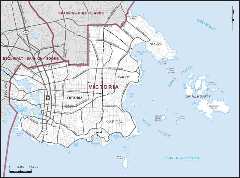
Victoria*
*NOTE: This map comes from the 2013 Representation Order. It will be in effect for the next general election called after May 1, 2014. Go to the maps currently in effect.
 |
| http://www.elections.ca/res/cir/maps2/images/atlas/59041.pdf |
Boundaries description
Consisting of those parts of the Capital Regional District comprised of:
- (a) the City of Victoria;
- (b) the District Municipality of Oak Bay;
- (c) that part of the District Municipality of Saanich lying easterly and southerly of a line described as follows: commencing at the intersection of the southerly limit of said district municipality with Shelbourne Street; thence northerly along said street to McKenzie Avenue; thence easterly and southeasterly along said avenue to Finnerty Road; thence northeasterly along said road to Arbutus Road; thence northerly along said road to Hollydene Place; thence northeasterly and northwesterly to the end of said place; thence northeasterly in a straight line to the easterly limit of said district municipality at approximate latitude 48°28'38"N and longitude 123°18'02"W; and
- (d) those parts of Subdivision H (Part 1) comprised of:
- (i) that part lying southeasterly of a line described as follows: commencing at a point on the westerly limit of said subdivision located at approximate latitude 48°28'38"N and longitude 123°18'02"W; thence northeasterly in a straight line to the northerly limit of said subdivision located at approximate latitude 48°30'12"N and longitude 123°16'13"W;
- (ii) that part lying easterly of a line described as follows: commencing at the southerly intersection of the eastern limit of the District Municipality of Esquimalt with the western limit of the City of Victoria; thence southerly along the western limit of the City of Victoria to the southwesternmost point of said limit located westerly of Ogden Point; thence southerly in a straight line to the southerly limit of said subdivision at approximate latitude 48°15'00"N and longitude 123°25'49"W.
http://www.elections.ca/res/cir/maps2/mapprov.asp?map=59041&lang=e#descrip
No comments:
Post a Comment